


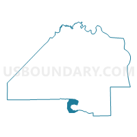
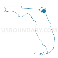
6E-Voting District, Duval County, Florida
About
Outline

Summary
| Unique Area Identifier | 552761 |
| Name | 6E-Voting District |
| County | Duval County |
| State | Florida |
| Area (square miles) | 10.42 |
| Land Area (square miles) | 1.41 |
| Water Area (square miles) | 9.01 |
| % of Land Area | 13.52 |
| % of Water Area | 86.48 |
| Latitude of the Internal Point | 30.16507950 |
| Longtitude of the Internal Point | -81.64886160 |
Maps

Graphs
Select a template below for downloading or customizing gragh for 6E-Voting District, Duval County, Florida


Neighbors
Neighoring Voting District (by Name) Neighboring Voting District on the Map
- 103-Voting District, St. Johns County, FL
- 14N-Voting District, Duval County, FL
- 208OP-Voting District (Orange Park Municipal), Clay County, FL
- 402-Voting District, Clay County, FL
- 6A-Voting District, Duval County, FL
- 6C-Voting District, Duval County, FL
- 6F-Voting District, Duval County, FL
- 6G-Voting District, Duval County, FL
- 6T-Voting District, Duval County, FL
- 6V-Voting District, Duval County, FL
- 6W-Voting District, Duval County, FL
Top 10 Neighboring County Subdivision (by Population) Neighboring County Subdivision on the Map
- Jacksonville East CCD, Duval County, FL (416,827)
- Jacksonville West CCD, Duval County, FL (312,199)
- Orange Park CCD, Clay County, FL (89,647)
- Fruit Cove CCD, St. Johns County, FL (36,523)
Top 10 Neighboring Place (by Population) Neighboring Place on the Map
- Jacksonville city, FL (821,784)
- Fruit Cove CDP, FL (29,362)
- Fleming Island CDP, FL (27,126)
- Orange Park town, FL (8,412)
Top 10 Neighboring Unified School District (by Population) Neighboring Unified School District on the Map
- Duval County School District, FL (864,263)
- Clay County School District, FL (190,865)
- St. Johns County School District, FL (190,039)
Top 10 Neighboring State Legislative District Lower Chamber (by Population) Neighboring State Legislative District Lower Chamber on the Map
Top 10 Neighboring State Legislative District Upper Chamber (by Population) Neighboring State Legislative District Upper Chamber on the Map
Top 10 Neighboring 111th Congressional District (by Population) Neighboring 111th Congressional District on the Map
- Congressional District 7, FL (812,442)
- Congressional District 4, FL (744,418)
- Congressional District 3, FL (659,055)
Top 10 Neighboring Census Tract (by Population) Neighboring Census Tract on the Map
- Census Tract 168.04, Duval County, FL (7,697)
- Census Tract 208.01, St. Johns County, FL (7,308)
- Census Tract 307.01, Clay County, FL (7,048)
- Census Tract 168.03, Duval County, FL (6,908)
- Census Tract 306, Clay County, FL (4,451)
- Census Tract 167.11, Duval County, FL (4,311)
- Census Tract 208.03, St. Johns County, FL (4,153)
- Census Tract 168.08, Duval County, FL (3,494)
- Census Tract 132, Duval County, FL (2,311)
- Census Tract 168.01, Duval County, FL (2,203)
Top 10 Neighboring 5-Digit ZIP Code Tabulation Area (by Population) Neighboring 5-Digit ZIP Code Tabulation Area on the Map
- 32073, FL (38,920)
- 32259, FL (36,917)
- 32257, FL (36,430)
- 32003, FL (27,126)
- 32223, FL (23,980)
- 32212, FL (1,959)